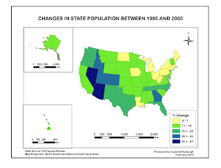
MAP 1. Percentage Population Change by State
I am still struggling with layers, but things are improving. I learnt how to proportionally constrain the size of a layer (other than by manual eyeballing), which is a useful skill. I had a few problems importing from ArcGIS, especially with regard to font and size. I think perhaps ArcGIS saves in an older version of AI. I had to redo some of the text in AI. Still a bit frustrating to work with AI, but I am beginning to see potential here.
MAP 2. Percentage Population Change by Division
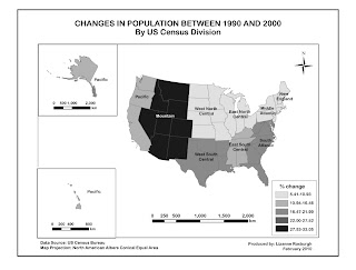
I wanted to make the divisions visually clearer and non-ambiguous but I could not figure out how to overlay pattern upon colour or how to outline a division with a darker colour. But I don't think it is that important to know exactly which state is in which division so the slight ambiguity should not be a problem. Nevertheless it would be good to find this out in future.
No comments:
Post a Comment